

Turnpoints
Latest files
Turnpoints
News
- 29 December 2013
-
New SeeYou Om2014.cup to match new Cambridge file with updated landouts to match the new Glide Omarama landout guide.
- 12 December 2013
-
Updates Omarama turnpoint file for changes to landouts. Killermont, Killermont Vegas, Dalrachney are gone. Added Birdwood, Matukituki, Whare Kea, Kokonga.
- 28 January 2013
-
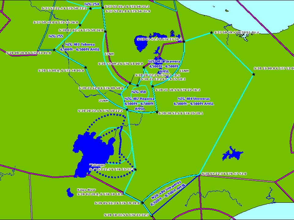
Airspace for Taupo airspace_2012.cub
- 21 August 2012
-
Updated Taupo turnpoints Taupo2012v2.cup
- 20 November 2011
-
Corrected an error in the names of the start points of the Omarama turnpoint file.
- 6 November 2011
-
Updated airspace to correct some error. TNP and CUB formats.
- 26 September 2011
-
Fresh turnpoints for Taupo in SeeYou .cup and Cambridge .dat formats.
- 9 September 2011
-
South Island airspace update courtesy of Max Stevens in TNP and SeeYou .cub format.
- 12 May 2011
-
Imported data from the new Air Navigation Register into the new airspace browser
- 26 March 2011
-
Added airspace browser , currently loaded with the Omarama / South Island airspace files.
- 24 December 2010
-
Cambridge data file with numeric prefixes to make loading task easier for contests. Supplied by Max Stevens.
- 16 November 2010
-
Updated Cambridge .dat file so the start and nav points are also turnpoints so the Cambridge GPS nav lets you see them.
- 1 October 2010
-
New waypoints for Omarama. Many changes. Available as Cambridge .dat file or SeeYou .cup file.
- 31 January 2010
-
Airspace file (Nationals2010.sua) for the Taupo Nationals.
- 21 January 2010
-
Turnpoint file (2010Taupo.dat) for the Nationals at Taupo in February.
- 21 December 2009
-
New Omarama airspace files in TNP format for SeeYou etc, and in OpenAir format for XCSoar and Winpilot.
- 20 December 2008
-
Converted TNP airspace file into OpenAir format for WinPilot and XCSoar. This file, Om2008.txt is also just for the Omarama area.
- 4 November 2008
-
New airspace file in TNP format, Om2008.sua for the Omarama area.
- 1 November 2008
-
New Cambridge file GO2008.dat with updated landout information to match the Glide Omarama landout guide and the new South Island gliding maps. This file has also removed to old start points used when contests tried multiple start cylinders.
- 23 July 2008
Corrected location of Chateau airstrip in UpperNth.dat. Was at the hotel rather than at the airfield by the turnoff on the main road. Trevor Terry noticed the error.
- 28 May 2008
-
Found and fixed a small error in Om2007.dat. It was missing a 'F' for feet in the elevation of turnpoint 1130.
- 23 May 2008
-
Russell Thorne has updated the upper North Island landout list. Available in Cambridge format UpperNth.dat or you can view the landouts on a Google map
- 18 April 2008
-
Deleted 208 Pinnacle Hill from the Matamata database. This is a landout point that is no longer landable. Matamata07.dat Landout map Turnpoint map
- 12 December 2007
-
Due to problems reported with the airspace file a small subset of the airspace for Omarama to Queenstown has been prepared. This will get rolled in to the full file when time allows. The file is Om2007.sua.
- 10 December 2007
-
Updated the Omarama turnpoint file for two new landouts. L340 Pukaki River Flats, and L225 Guide Hill. The new file in Cambridge format is Om200712.dat. These are in the new Glide Omarama Landout Guide booklet.
- 27 November 2007
-
Added NZA141 and NZA152 to airspace file from files supplied by Russell Thorne.
- 18 November 2007
- 10 November 2007
-
Regenerated Cambridge turnpoint file with outlanding strip updates: Om200711.dat
- 20 August 2007
-
Added a few new strips from Chris Streat and make a new Cambridge file: Om200708.dat
- 17 July 2007
-
Got reports of problems with the airspace file and when I had a look I'd forgotten to link to the latest version. I also have a viewer for the airspace definitions to help debug things if some of the airspace looks wrong.
- 12 July 2007
-
Russell Thorne has added landouts to the Matamata turnpoint list. The usual rules apply. The landout points are just a guide. Look out the window. If a farmer puts a fence across the field he isn't going to tell us, so always check before relying on these points. Please tell us if there are any errors so we can correct them.
Updated Matamata turnpoints in cambridge format. You can view the landouts on a Google map. Some areas have high res satellite pictures that give a very good idea of what the area looks like from the air.
- 9 July 2007
-
Updated Omarama turnpoints in cambridge format. The only changes are some of the landout points.
- 7 July 2007
-
New airspace is coming. So far I've got Control Areas under way. You can view the definitions I'm working from with my new viewer.
- 27 June 2007
-
Added the Nelson turnpoints in Cambridge format and a map for Nelson
- 2 Feb 2007
-
New turnpoint collection for the CDs at Waipuk. Also available on a Google map
- 16 Aug 2006
-
Added a map for Matamata
- 7 Aug 2006
-
Using the new Google map software I have made new maps that work with IE and allow selecting the view point.
- Feilding turnpoints.
- Masterton turnpoints.
- Omarama turnpoints.
- Paraparaumu turnpoints
- Taupo turnpoints.
- 15 July 2006
-
Updated the maps to use the new version of Google's map software. Currently we have available:
- Alps MBZ over and around Mt Cook.
- Airfields from the CAA's list of airfields.
- Reporting points from CAA's list.
- Feilding turnpoints.
- Masterton turnpoints.
- Omarama turnpoints.
- Omarama landouts.
- Paraparaumu turnpoints
- Taupo turnpoints.
- 28 Feb 2006
-
Updated Omarama turnpoints to remove non-existant airfield at Makarora.
- 20 Feb 2006
-
I have prepared a couple of XML files, one is the Omarama landout strips, from the current turnpoint list. The other is based on the list of airfield coordinates from the CAA website, with altitudes from http://www.aip.net.nz caa_airfields.xml
- 12 Feb 2006
-
Updated airspace to fix error in G959.
Updated Omarama turnpoints in Cambridge format with extra turnpoints for the GP, and removed Makarora airfield as it was incorrect. The Makarora turnpoint is the actual airfield.
- 31 Dec 2005
-
Some experimental stuff. A map with all the airfields in NZ. From the list of airfields on the CAA website. airfields.html A map with all the airfields and all the visual reporting points, also from the CAA website. Centered on the Mt Cook MBZ, with the MBZ shown. NZB978.html These don't work with Internet Explorer, but do with Firefox.
- 30 Dec 2005
-
Updated airspace file for seeyou etc is available. nz200511.air. Please send any corrections to Philip Plane.
- 1 Nov 2005
-
Lex has made a correction to the Cambridge format to make the turnpoints easier to use and provided the file in some different formats.
- 29 Nov 2005
-
All Turn Points and Land-outs for Omarama have been completely revised for the 2005 - 2006 season by Richard Halstead and Gavin Wills . Every Omarama contest pilot will need to upload this new data base. It is called Omarama2005.
A summary of changes are as follows:
- Eleven new Turn-Points added.
- Every turn point number has changed negating the old turn point maps.
- The Land-out points numbers are unchanged but they have been physically visited and some unserviceable strips removed.
A new Map called the Omarama Gliding Map is being printed by Airways and will be available for sale at the Regionals or from GlideOmarama.com after November 10. The Omarama Gliding Map is 1:500,000, orientated NE to SW (like the old 95 Worlds Map) and covers the Omarama gliding terrain from Arthur's Pass to Lake Te Anau. The Map will contain the new Turn Points, the land-out strips as well as current airspace.
Cambridge format available for download now.
A separate data base for the Omarama Grand Prix will be published shortly. This data base is required ONLY for Grand Prix racing pilots
- 10 Oct 2005
-
New turnpoints for Matamata from Dennis Cook. Cambridge format available for download now.
These four points are deleted.
- 106 Otorohanga A
- 109 Rangataiki A
- 113 Te Aroha A/F
- 117 Thames A/F
Otorohanga and Te Aroha are no longer airfields, '117 Thames A/F' has been confused with '07 ThamesA/F' and '109 Rangataiki A' can be confused with '41 Rangataiki'
The database will be updated shortly.
- 21 Sep 2005
-
New turnpoints for the Taupo contests from Trev Terry. cambridge and SeeYou format files are available. The database will be updated shortly.
- 24 December 2004
-
Updated Omarama with changed ID numbers. Only some numbers changed.
- 5 December 2004
-
New turnpoint list for Omarama from 2003 is not yet in the database. A cambridge format turnpoint file is available.
- 3rd November 2002
-
Database updated with new turnpoints for Omarama. Exporting in Cambridge format now uses seperate names.
- 2nd November 2002
-
New turnpoints for South Island Regional contest recieved from Tim Harrison in a variety of formats. The database will be updated shortly.
Format Turnpoints Turnpoints & Landing Ilec SN10 Reg2002.ndb Reg02_L.ndb Print Technic Reg2002.cup Reg02_L.cup Cambridge Reg2002.dat Reg02_L.dat Volkslogger Reg2002.dbt Reg02_L.dbt Filser Reg2002.da4 Reg02_L.da4 - 20th February 2001
- Added Wharite turnpoint.
- 19th February 2001:
- Added three new turnpoints at Matamata. Cleaned up some turnpoint
names in the database that had trailing spaces.
- 16th January 2001:
- Corrections to two of the Masterton turnpoints, and improvements
to the export for gardown format.
- 26th December 2000:
- New turnpoints for Masterton. Most coordinates have changed, but
only by a few meters. Added Papawai airfield and Ohakea, Napier, and Wellington
to assist in position reporting.
- 7th December 2000:
- New Omarama turnpoints are in. No garmin short names yet.
Just use the numbers.
Display is now only three decimal places, to ease manual loading into garmin GPS.
Short names will be added soon, and work is progressing on the export/ download.